

Drone Inspection & Surveying Services
Filters
Structured Directory of Drone Inspection and Surveying Services
The integration of Unmanned Aerial Vehicles (UAVs or drones) into industrial, construction, and agricultural sectors has fundamentally transformed how infrastructure is inspected and monitored. Tasks that historically required expensive scaffolding, cranes, and significant human risk—such as inspecting high-rise building facades, wind turbines, or expansive solar farms—are now conducted via drones faster, safer, and with pinpoint accuracy. In Armenia, driven by the rapid growth of the solar energy sector and real estate development, the demand for highly specialized drone inspections has surged. Turn.am provides a comprehensive directory connecting project managers, engineers, and property owners with certified drone operators equipped with enterprise-grade technology to solve complex aerial challenges.
Core Categories of Drone Inspection Services
Industrial drone services go far beyond standard cinematic videography. On our platform, services are categorized by their specific technical application and sensor payloads:
- Visual Asset & Roof Inspections: Utilizing high-resolution zoom cameras to safely inspect hard-to-reach areas like commercial roofs, bridges, telecommunication towers, and factory facades to identify structural cracks, leaks, or corrosion.
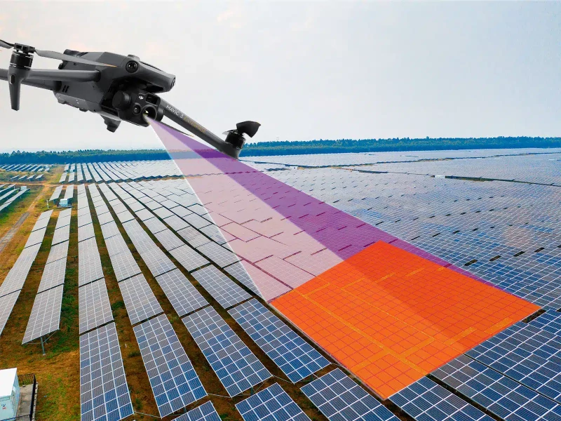
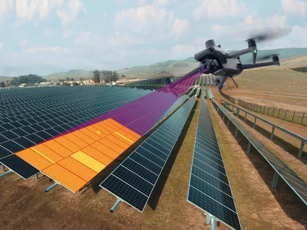
- Thermal Imaging (Thermography): Deploying drones equipped with radiometric thermal sensors to detect anomalies. This is critical for identifying defective cells in solar photovoltaic (PV) plants, finding heat leaks in building envelopes, and inspecting high-voltage power lines.
- Photogrammetry & 3D Mapping: High-precision aerial surveying to create orthomosaic maps, digital elevation models (DEM), and highly accurate 3D point clouds for construction planning and land surveying, often utilizing RTK (Real-Time Kinematic) modules for centimeter-level accuracy.
- Agricultural Multispectral Surveying: Precision agriculture services using multispectral cameras to capture data beyond the visible light spectrum. This allows farmers to calculate vegetation indices (like NDVI) to assess crop health, optimize irrigation, and target fertilizer application.
- Construction Progress Monitoring: Scheduled, repeatable drone flights over construction sites to provide stakeholders with visual data, volumetric measurements of stockpiles, and timeline documentation to ensure projects stay on track.
How Turn.am Connects You with Aerial Experts
Turn.am acts as a transparent hub for finding specialized aerial data providers. Not all drone operators have the equipment required for industrial tasks. Our attribute-based filtering system allows you to search for specialists who possess enterprise-level drones (such as the DJI Enterprise series) equipped with specific payloads like thermal cameras or LiDAR sensors. Furthermore, reviews on Turn.am are directly tied to the specific service rendered. You can read actual client feedback regarding an operator's ability to "deliver an accurate solar thermography report" or "provide precise 3D models for a CAD integration," ensuring you hire a professional with both the right hardware and the analytical expertise required for your project.
